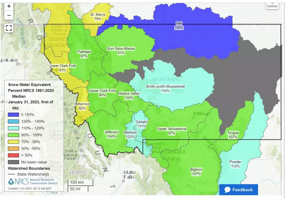
Western Montana winter precipitation report
As we slowly grind our way through winter, let’s look at the current snowpack in western Montana and what that means to the water basins.
As of January 31st, the Month to Date Precipitation across Montana is generally below the 1991-2020 average, but not by much.
The green on the map above shows 90%-109% of the average for the month of January. Those areas include the Flint Creek basin, the Upper Clark Fork, the Boulder (Jefferson), the Helena Valley, and the Smith. But just south of Butte, the Big Hole basin is only at 60% of the January average. That red horseshoe around the Flathead all comes in at less than 50%, the Bitterroot at 48%, Lower Clark Fork at 46%, and the lowest, the St.Mary’s basin at 28%. Again, these numbers are only for January.
Here is a look at the Full Water Year (October 1 to current)
The full water year map looks much better. We may have been a bit light on snow in January, but the start of winter made up for it. The Green areas again show 90-109% of average. The yellow again showing 70-89% of average (the Big Hole basin shows 85% of average as of yesterday) And how about that blue! The Ruby basin shows 120%, the Madison at 114%, and North Central Montana’s Musselshell and Judith basin at 119%. Hopefully a little relief for those areas that have been hammered by drought.
This last map shows snow depth at various measuring stations. Again, it makes a person hopeful looking at these numbers. Most areas seem to be in the 25 – 50-inch range. Just north of Missoula, Stuart Mountain measures 72 inches, and north of Flathead, the Noisy basin is measuring 87 inches. The deepest snow measurement reported in Montana is just south of Flathead, Moss Peak at 97 inches.
Our projected Montana February forecast shows below-average temperatures and above-average precipitation.
The maps and all information is from the USDA Natural Resource Conservation Service, National Water and Climate Center WEBSITE.
To satisfy my curiosity I had to look.
The deepest snow in the Western United States as of today is in the Sierra Nevada Mountains of California, with several readings well over 100 inches.
The deepest snowpack in the Western United States? Leavitt Lake, California with 178 inches of snow, so far.

LOOK: The most extreme temperatures in the history of every state
KEEP READING: Get answers to 51 of the most frequently asked weather questions...
More From 95.5 KMBR


